Use the power of maps to manage your maintenance workflows easily and automate a slew of back office operations. Save valuable time and money while improving compliance and communications with your stakeholders. A serious win-win
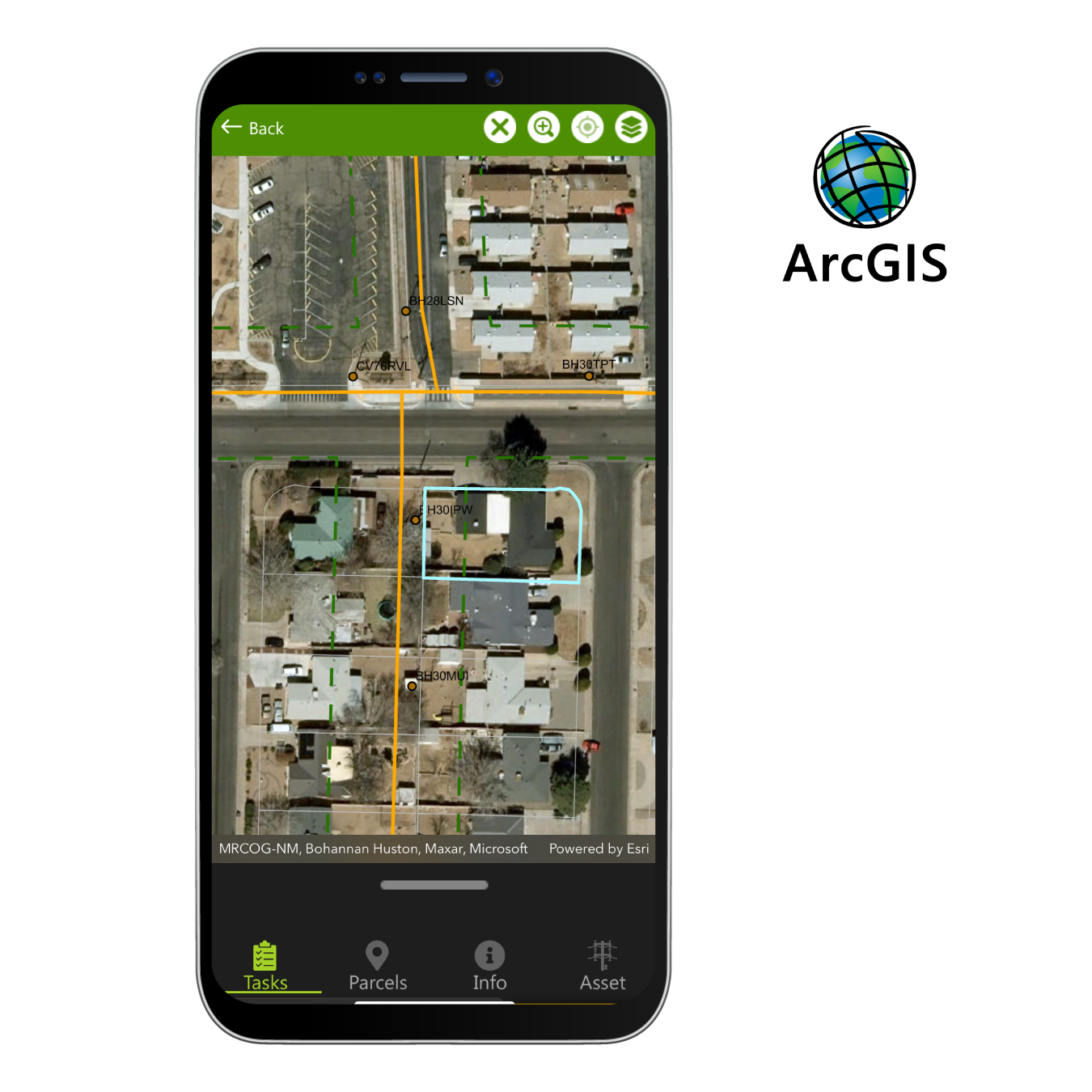
Clearion is built to work natively on the ESRI ArcGIS platform. This includes Esri’s Portal for user management and integration with 3rd Party Identity Providers with security options such as, SAML, Single Sign-On, and more. We support a variety of different deployment patterns with ArcGIS Online and Enterprise to ensure your data is secure and accessible while extending Esri group-level administration of content to support internal and external users. This includes data management from ArcGIS server or hosted in ArcGIS Online. Our app can also be deployed alongside Esri’s off-the-shelf apps like Survey123 and Field Maps
Integrated Work Management
Improve insight and effectiveness of your field operations
Managers & Supervisors
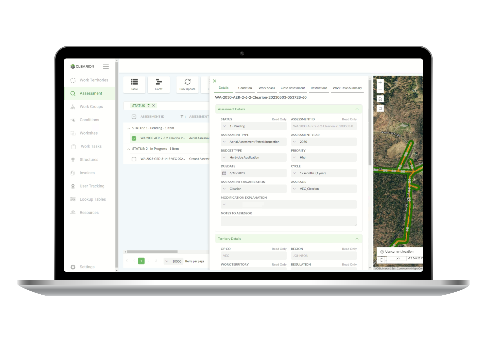
Job Management
Schedule jobs, assign people and equipment, and perform other administrative activities including tracking and reporting. Optimize your crew, supervisors, inspectors and arborists work schedules to get your vegetation and infrastructure management jobs done safely and on time
Field Crews & Contractors
Field Work
Receive and track field work tickets directly on your phone or tablet. Organize complex information such as regulation information, weather, inspection details, and job details using the power of maps. Perform mass updates for spans or regions to minimize data entry and keep your workers focused and productive
Executives & Supervisors
Dashboards
Access information and gain real-time insights about work progress by simply logging into a URL. Perform advanced analysis directly from Clearion Mobile or Work Manager applications without having to access a separate reporting tool. What’s more, it incorporates data from external sources and can plug into external reporting programs such as Tableau and PowerBI
Cross-Platform Work Management
All functionality is accessible on iOS, Android, and Windows 10 devices, and in a variety of formats including desktop, tablet and phone. This gives organizations incredible flexibility when it comes to creating project based teams that may have company-issued, bring-your-own, or external vendor devices
Features - better way to manage field work
Innovative, practical, and powerful ways to transform your field work — powered by Esri ArcGIS maps
Online and Offline
Clearion supports an intelligent, on-demand process for bringing all field work offline so there is no sacrifice in capabilities in areas that have no cell or data connection
Easy Installation
As a cross-platform application, Clearion is easily accessible from all the major app stores for download. Users are typically up and running in less than 2 minutes
Create, Update & Automate
Streamline data entry with our highly configurable automation capabilities to capture current date and user, inherit data, and create custom rules based on various data conditions
Map to List Integration
The map and the list are tightly integrated. With one tap in the list or the map, the item is highlighted in the other
3rd Party Data
The applications consume standard Esri feature services and web maps making it easy to consume data from other internal as well as external data sources
Extensible User Roles
Extend capabilities to internal and external users like a 3rd party contractor or vendor using workflows with configurable roles that allow you to restrict data and functionality access
Searchable
Pinpoint specific structures or locations using advanced search capabilities, using various map views to validate your findings
Bulk Updates
Quickly update work for multiple locations using spans or regions on a map, and speed up capture further with auto-completions for things like name and date
Open Source Configuration
Clearion can connect to any schema and Esri data, and we can easily modify the behavior of the app through open-source configuration – meaning zero custom code
Smart Forms
Configure intelligent forms that filter options based on previous field entries, so field personnel spend less time searching through dropdowns and more time filling out key information
Zoom In & Out / Spatial Work Plans
Zoom in to give precise work instructions, make assignments, and set schedules and zoom out to build budgets and establish annual plans, including yearly patrol schedules
Secure
Leverage Esri named users for security and identify (role) management
Compliance
Configure inspection workflow to deliberately manage the inspection process and track the history of significant actions to create robust compliance information
Desktop Patrol
Use 3D visualization tools to inspect LiDAR POI’s and prescribe work directly to crews in Clearion from the desktop
From Our Customers
“The Clearion Team has played a central role in the early success and continued progress of our digital transformation effort. We’ve leveraged our city’s investment in GIS data and our Esri ELA, meeting a central goal of the project. The PUC team has benefited from an easy implementation, excellent support, and the flexibility of the Clearion solution to truly make the system their own.”
Robert Brewer, CEO
“We’re pleased to have been recognized by the PUC as an industry leader for our new VM system. Our customers value uninterrupted service, and this software will help us continue to provide the exceptional service that our customers have come to expect from us.”
Jim Barry, Senior manager, vegetation management
What can Clearion do for you?
Contact us to schedule your free introductory call
Contact us
"*" indicates required fields
We use cookies on our website to give you the most relevant experience by remembering your preferences and repeat visits. By clicking “Accept”, you consent to the use of ALL the cookies.
This website uses cookies to improve your experience while you navigate through the website. Out of these, the cookies that are categorized as necessary are stored on your browser as they are essential for the working of basic functionalities of the website. We also use third-party cookies that help us analyze and understand how you use this website. These cookies will be stored in your browser only with your consent. You also have the option to opt-out of these cookies. But opting out of some of these cookies may affect your browsing experience.
Necessary cookies are absolutely essential for the website to function properly. These cookies ensure basic functionalities and security features of the website, anonymously.
Cookie
Duration
Description
cookielawinfo-checkbox-analytics
11 months
This cookie is set by GDPR Cookie Consent plugin. The cookie is used to store the user consent for the cookies in the category "Analytics".
cookielawinfo-checkbox-functional
11 months
The cookie is set by GDPR cookie consent to record the user consent for the cookies in the category "Functional".
cookielawinfo-checkbox-necessary
11 months
This cookie is set by GDPR Cookie Consent plugin. The cookies is used to store the user consent for the cookies in the category "Necessary".
cookielawinfo-checkbox-others
11 months
This cookie is set by GDPR Cookie Consent plugin. The cookie is used to store the user consent for the cookies in the category "Other.
cookielawinfo-checkbox-performance
11 months
This cookie is set by GDPR Cookie Consent plugin. The cookie is used to store the user consent for the cookies in the category "Performance".
viewed_cookie_policy
11 months
The cookie is set by the GDPR Cookie Consent plugin and is used to store whether or not user has consented to the use of cookies. It does not store any personal data.
Functional cookies help to perform certain functionalities like sharing the content of the website on social media platforms, collect feedbacks, and other third-party features.
Performance cookies are used to understand and analyze the key performance indexes of the website which helps in delivering a better user experience for the visitors.
Analytical cookies are used to understand how visitors interact with the website. These cookies help provide information on metrics the number of visitors, bounce rate, traffic source, etc.
Advertisement cookies are used to provide visitors with relevant ads and marketing campaigns. These cookies track visitors across websites and collect information to provide customized ads.